Rangitoto Island
A young volcano 25–30 minutes by ferry from downtown Auckland, with a hard stop at the last boat. No shops, no water, no camping.
January, this month96/100February, this month92/100March, this month86/100April, this month73/100May, this month51/100June, this month37/100July, this month31/100August, this month40/100September, this month55/100October, this month68/100November, this month87/100December, this month92/100
How the score works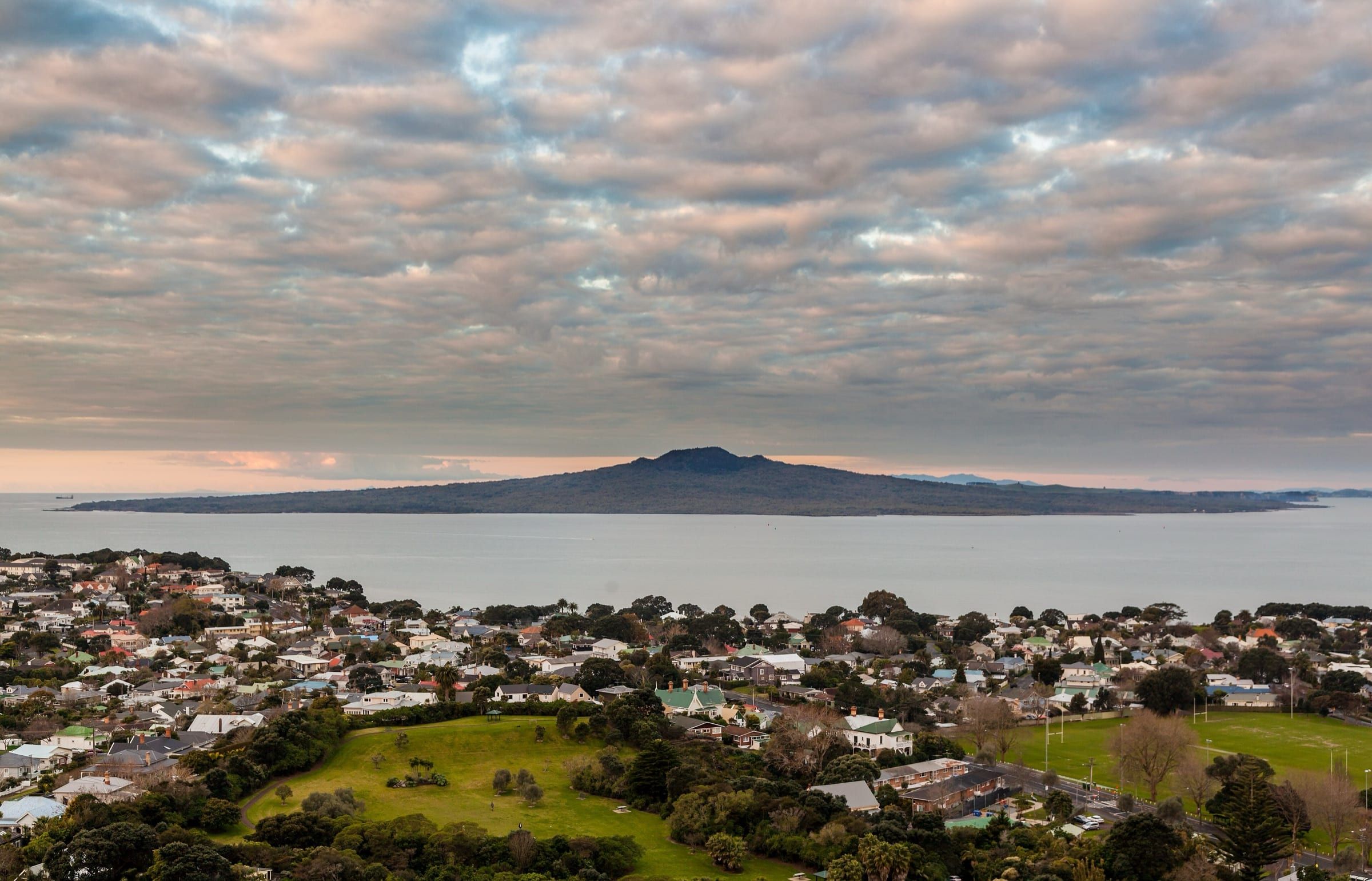

At a glance
Getting there from New Zealand
- Auckland
- FerryFullers360about 30 min
- Wellington
- Fly to Auckland, then ferryAir New Zealand and Fullers360about 2 h 30 min
- Christchurch
- Fly to Auckland, then ferryAir New Zealand and Fullers360about 3 h
Typical scheduled times from each airline or operator. With a change, we allow 1 h 30 min to change planes and 1 h to get from an airport to a boat or onward flight.
- Time
- Same time as NZ
- Money
- NZ dollarsThe same money as at home, so nothing to change.
- Entry
- No visa needed with an NZ passport.Entry rules in Know before you go
- Plugs
- Type I, the same as NZ
- Driving
- On the left, as in NZ
- Language
- English and te reo Māori
- Cost
- Cheaper than NZ
- The island
- 23 km² of land · highest point 260 m
The short version
Rangitoto is a volcanic island in the Hauraki Gulf/Tīkapa Moana that rose from the sea about 600 years ago, making it New Zealand’s youngest volcano. The public ferry from downtown Tāmaki Makaurau Auckland takes about 25 to 30 minutes. The classic outing is the Summit Track: 7 km return, about two hours, through black lava fields and what DOC calls the largest pōhutukawa forest in the world.
This is a day trip, not a holiday. There are no shops, no drinking water and no rubbish bins, camping is not allowed, and the only beds are three restored baches that run off-grid. It suits walkers, school-age children who like caves, and anyone adding a half day outdoors to a stay in Auckland. For Kiwis flying in from Wellington or Christchurch, it is an add-on to an Auckland trip, not a reason to fly.
The catch is the clock and the terrain. On the current timetable the last ferry back leaves at 3.30pm on weekdays and 4pm at weekends, the lava is rough underfoot, and there is little shade. Our verdict: a very good half day for anyone in sturdy shoes, as long as you plan around the last boat.
Who Rangitoto Island suits
Each score is out of 5, against the other islands we cover.
Best for
- Nature: 4 out of 5.The largest pōhutukawa forest in the world, according to DOC, with saddleback, kākā and tūī on a pest-free island.
- Value for money: 4 out of 5.The ferry fare is the main cost of the day, and there is nothing on the island to spend money on.
- Families: 3 out of 5.The Lava Caves Track suits kids, but there are no shops, drinking water or bins, and the ground is rough.
The catch
The last ferryThe last boat back leaves in the afternoon, the lava is rough underfoot, and there is little shade on the climb.
Show the other nine ratings
- Adventure: 3 out of 5.Lava fields, a dark lava cave, long coastal tracks and a guided sea-kayak crossing, though the main track is not hard.
- Couples: 2 out of 5.A two-hour summit walk with Hauraki Gulf views makes a good day for two, but there are no shops and the only beds are baches with no hot water.
- Culture: 2 out of 5.Māori associations, a wartime harbour-defence past and about 30 surviving 1920s and 1930s baches, but heritage is a side theme to the volcano.
- Rest: 2 out of 5.Quiet if you stay in an off-grid bach, but a day trip is a timed walk with a last ferry to catch.
- Honeymoons: 1 out of 5.No hotels or restaurants, and the baches have no hot water: a day out rather than a honeymoon.
- Beaches: 1 out of 5.Swimming spots such as McKenzie Bay and Islington Bay are a 1.5 to 2.5 hour walk from the wharf, so this is not a beach day.
- Snorkelling and diving: 1 out of 5.DOC lists Wreck Bay’s ship graveyard as a good snorkelling and diving spot, but it is a long walk or boat trip away.
- Food and wine: 0 out of 5.There are no shops on the island, so you carry in every sandwich and every drop of water.
- Luxury: 0 out of 5.No hotels, restaurants or shops; the only beds are three restored baches with no hot water.
When to go
Rangitoto has no wet or dry season to plan around. NIWA describes Auckland’s climate as subtropical, with warm, humid summers, mild winters and rain through the year. The better question is what black rock does to a walker. DOC warns that heat reflects off the lava and that there is little shade, and wasps increase over the warmer months. Our pick for walking is spring or autumn, when Auckland Tourism describes the days as mild.
Each season has a small draw. The kōwhai grove near the wharf is at its best in spring when the trees flower, the kidney ferns look best after rain, and the pōhutukawa bloom around Christmas. Winter is cooler and wetter with shorter days, which matters because the last ferry leaves in mid-afternoon. One booking-site listing says that in bad weather ferries may use Islington Bay Wharf instead, adding up to an hour of walking to and from the summit.
Crowds are mostly a school-holiday story. Auckland Tourism says ferries and beaches can be busier around Christmas, New Year and the school holidays. The summer break starts no later than 19 December 2026 and lasts five or six weeks, and the 2027 term holidays fall on 10–26 April, 3–18 July and 25 September–10 October. We found no recurring public events on the island itself, so there is nothing to time a trip around.
Best from November to FebruaryHighest score 96 (excellent) in January; lowest 31 (poor) in July.
Show the numbers
| Month | Score | Rating | Air high °C | Air low °C | Sea °C | Rain mm |
|---|---|---|---|---|---|---|
| January (best months) | 96 | Excellent | 24 | 15 | 20 | 71 |
| February (best months) | 92 | Excellent | 24 | 16 | 21 | 71 |
| March | 86 | Excellent | 23 | 15 | 21 | 72 |
| April | 73 | Good | 21 | 13 | 19 | 90 |
| May | 51 | Fair | 18 | 11 | 18 | 123 |
| June | 37 | Poor | 16 | 9 | 16 | 118 |
| July | 31 | Poor | 15 | 9 | 14 | 129 |
| August | 40 | Poor | 16 | 9 | 14 | 102 |
| September | 55 | Fair | 17 | 10 | 14 | 94 |
| October | 68 | Good | 18 | 11 | 15 | 88 |
| November (best months) | 87 | Excellent | 20 | 12 | 17 | 65 |
| December (best months) | 92 | Excellent | 22 | 14 | 19 | 85 |
NZ school holidays shown, 16 October 2026 to 15 October 2027: 19 December 2026 to 27 January 2027; 10–26 April 2027; 3–18 July 2027; 25 September to 10 October 2027.
Where to stay
Almost everyone sleeps in Auckland and takes a morning ferry. The only beds on the island are three historic baches, so the choice is between a base near the ferry terminals and a night off-grid.
© OpenStreetMap contributors
On the mainland, not marked here: 1 Downtown Auckland and 2 Devonport.
Downtown Auckland
The Rangitoto ferry leaves from the Downtown Ferry Terminal, Pier 14. Staying within walking distance makes the 9.15am or 9.30am sailing easy, which gives you the longest day on the island before the last boat back.
Best for
See stays in Downtown Auckland, on Booking.com (opens in a new tab)
Devonport
Some sailings call at Devonport on the North Shore, and the crossing from there to Rangitoto Wharf is about 20 minutes. A North Shore base if you are happy to catch the ferry across the harbour.
Best for
Bach 52, Rangitoto Wharf
A restored 1920s bach near the start of the Summit Track, off-grid with solar lights, gas cooking and no hot water. Sleeps up to seven, with a two-night minimum. Bring your own linen and all your food and water.
Best for
See stays in Bach 52, Rangitoto Wharf, on Booking.com (opens in a new tab)
Islington Bay baches
Baches 78 and 114 sit by Islington Bay, a 1.5 hour walk from Rangitoto Wharf or two minutes from Islington Bay Wharf. Both are off-grid, with chemical or long-drop toilets and no hot water. Book through the listing and plan your boat.
Best for
See stays in Islington Bay baches, on Booking.com (opens in a new tab)
Things to do
Rangitoto is a walking island: a volcano summit, a lava cave, old baches and a forest that grew on bare rock. Most of it fits into one ferry-to-ferry day, but not all of it.
Rangitoto Summit Track
DOC gives 2 hours and 7 km return, with 250 m of climbing through lava fields and pōhutukawa forest. A viewing platform looks into a crater 60 m deep, and the Summit Lookout has panoramic views of Auckland and the Hauraki Gulf.
Lava Caves Track
A side track off the Summit Track, 45 minutes from the wharf, then 15 minutes and 500 m one way to natural lava tunnels. DOC calls it a great option for kids, but the caves are dark with low ceilings and unstable rock: bring a torch.
Historic baches and Flax Point
About 30 bach holiday homes from the 1920s and 1930s survive. The first stretch of the one-hour return walk to Flax Point passes several, and Bach 38 by the wharf is a museum open on some weekends and by appointment.
Pōhutukawa forest and native birds
Listen for saddleback, whitehead, kākā and tūī on the way up. In spring the kōwhai grove near the wharf flowers, kidney ferns look their best after rain, and the pōhutukawa bloom around Christmas, per DOC.
Wreck Bay ship graveyard
At least 13 old ships were dumped around Wreck Bay between 1887 and 1947, and remains show at low tide. It is a long extra walk from the wharf, so it suits overnight guests, not day-trippers on a 3.30pm ferry.
Guided sea-kayak trip
Auckland Sea Kayaks runs a day tour of about 6.5 hours and a sunset tour of 6 to 7 hours to Rangitoto, from NZ$220 a person on its site. DOC says the paddle suits experienced kayakers, so a guide is the sensible way.
Find tours: Guided sea-kayak trip, on GetYourGuide (opens in a new tab)
Overnight in a historic bach
Three restored baches can be rented: Bach 52 by the wharf and Baches 78 and 114 at Islington Bay. They are off-grid with solar lights and gas cookers, so you carry in food, water and linen and take every scrap of rubbish out.
Partner link: we may earn a commission. It never changes our verdicts. It goes to GetYourGuide. How we make money
Getting there
Fly to Auckland first. Air New Zealand’s Wellington–Auckland flight takes about 1 hour 5 minutes, with up to 14 non-stop flights a day. Christchurch–Auckland takes about 1 hour 25 minutes, with more than 10 a day. Then go to the Downtown Ferry Terminal, Pier 14, where the Rangitoto sailings leave.
Fullers360 runs the scheduled public ferry. In Auckland Transport’s published timetable data for 30 September 2026 to 24 January 2027, weekday sailings leave Downtown at 9.30am, 10.30am and 12.15pm, and weekend sailings at 9.15am, 10.30am and 12.15pm. Two of the three call at Devonport on the way. Boats back leave Rangitoto at 12.45pm, 2.30pm and then 3.30pm on weekdays or 4pm at weekends. On 26 October, 25 December and 28 December 2026 the weekend pattern applies. Summer timetables change, so confirm with the operator before you travel.
You can also reach the island by water taxi or charter. DOC lists the operators that hold a Pest Free Warrant, and Auckland Sea Shuttles is a water taxi service that serves the Hauraki Gulf. Auckland Sea Kayaks runs guided paddles. DOC says experienced kayakers can paddle from Auckland’s North Shore to Rangitoto Wharf in about two hours. Private boats may use the wharves only to load and unload passengers.
Getting around
You get around on foot. From Rangitoto Wharf, pass the carved gateway and take the signposted Summit Track on your left, just past the historic Scouts bach. DOC rates it easy to intermediate, with loose, slippery gravel and stones. Side trips are the crater rim loop (20 minutes) and the Lava Caves Track (15 minutes one way). DOC says its track times are indicative only.
Longer walks suit overnight guests more than day-trippers. The inland road to Islington Bay Wharf takes 1 hour 30 minutes, the coastal track 2 hours 30 minutes, and the lighthouse walk to McKenzie Bay 2 hours 30 minutes one way. A causeway built in World War II joins Rangitoto to Motutapu Island, and prisoners hand-packed some of the roads and trails you walk on in the 1920s and 1930s.
For mobility, DOC does not list the Summit Track as wheelchair accessible and says there are no accessible toilets. Boardwalks near the wharf and on the summit track are high in places, with falls of up to 2 m. DOC’s pages say nothing about bicycles, so ask before bringing one.
Money
Everything is in New Zealand dollars, and there is nothing to buy on the island, so your costs are the ferry, your food from the mainland and anything you book. One booking-site listing shows NZ$30 for an adult and NZ$13 for a child aged 5–15 for 12–25 October 2026, priced each way, so a same-day return is NZ$60 for an adult. Listings differ, so treat that as a guide and check the operator’s live fare.
Staying overnight costs more. The historic baches start at NZ$165 a night for two guests, rising to NZ$180 from 1 December to 31 March, with NZ$20 for each extra guest and a NZ$50 booking fee. Optional cleaning is NZ$100 in cash. A guided sea-kayak trip starts at NZ$220 a person. Air New Zealand’s one-way fares to Auckland start from NZ$99 on selected dates, but vary widely by day.
Know before you go
New Zealand citizens need no visa or NZeTA to enter New Zealand, as of October 2026, and DOC says no booking is needed for the Summit Track. Most overseas visitors need a visa or NZeTA for New Zealand, while Australian citizens need neither. Check Immigration New Zealand before you travel.
Rangitoto and Motutapu have been pest-free since 2011, and biosecurity is the rule that surprises people. Pack food in sealed containers, zip your bags, and clean soil and seeds from shoes and gear before you leave. Scrub your shoes at the pier cleaning stations, because rangers may recheck gear on arrival. Dogs are not allowed anywhere on the island, drones need a permit, and a total fire ban means no fires, cigarettes, barbecues or cookers.
Bring your own water, because there is none on the island. DOC lists toilets at the wharf and near the summit, but no food, water or bins. The lava caves are dark with low ceilings and unstable rock. Mobile coverage is missing in places, so tell someone your plans. The New Zealand emergency number is 111. Sun protection matters: SunSmart warns that New Zealand sunlight can have high UV levels, and DOC says the heat off the ground can be intense.
Māori have a strong association with Rangitoto but never lived there, using it as a lookout and a parrot reserve. DOC notes ancient burial caves on the island, and the full Māori name, Te Rangi-i-totongia-ai-te-ihu-o-Tamatekapua, recalls the day Tamatekapua’s blood was shed. Treat it as a place that matters to iwi today, not only as scenery.
What things cost
Prices from the sources below, in the currency they were quoted in and dated. They change, so treat them as a guide.
| What | Price |
|---|---|
| Ferry from downtown Auckland, each wayThe listing prices each leg separately, so a same-day return is NZ$60 per adult, with under-5s free. The operator’s own fares page could not be opened, and other listings show different adult prices, so confirm before you go. | NZ$30 adult, NZ$13 child aged 5–15 each way (booking-site listing, 12–25 October 2026) |
| Historic bach, two guestsExtra guests NZ$20 each a night, plus a non-refundable NZ$50 booking fee. Bach 52 has a two-night minimum. No linen provided. | NZ$165 a night, or NZ$180 a night from 1 December to 31 March (listings seen October 2026) |
| Optional bach cleaningArranged with the Island Bach Manager; otherwise leave the bach clean and tidy. | NZ$100 cash per booking |
| Guided sea-kayak trip to RangitotoAuckland Sea Kayaks’ day and sunset tours, lasting 6 to 7 hours, with food included on the sunset tour. | From NZ$220 per person (operator site, October 2026) |
| Air New Zealand Wellington–Auckland one-way seat fareFares change daily and the cheapest dates are limited. | From NZ$99, up to NZ$500 on peak October dates (seen October 2026) |
| Air New Zealand Christchurch–Auckland one-way seat fareFares change daily. | From NZ$99, up to NZ$459 on peak October dates (seen October 2026) |
Questions people ask
How long is the ferry to Rangitoto?
About 25 to 30 minutes from the Downtown Ferry Terminal in Auckland, and about 20 minutes from Devonport on the sailings that call there. Fullers360 runs the scheduled public service, and Auckland Transport’s data shows up to three sailings each way a day.
How long do I need on Rangitoto?
The Summit Track takes about 2 hours return, and the lava caves add 30 to 45 minutes. A booking-site listing suggests 4 to 5 hours at least. The latest return in the current data leaves at 3.30pm on weekdays and 4pm at weekends, so check the last boat before you set off.
Can I stay overnight on Rangitoto?
Only in one of three restored baches: Bach 52 at Rangitoto Wharf, and Baches 78 and 114 at Islington Bay. They are off-grid with no hot water, and you bring your own linen, food and water. Camping is not allowed on Rangitoto, according to DOC.
Can I take a dog, a drone or a barbecue to Rangitoto?
No to all three. DOC does not allow dogs anywhere on the island, flying a drone without a permit is prohibited, and portable barbecues and fires are banned, with a total fire ban in force.
Is Rangitoto suitable for young kids?
For school-age children who like caves, yes. DOC calls the Lava Caves Track a great option for kids. The ground is loose and uneven, boardwalks are high in places with falls of up to 2 m, and there is no drinking water, shop or bin, so pack for the whole day.
What should I bring to Rangitoto?
Water and food, sturdy shoes with good grip, a hat and sunscreen, a torch for the lava caves and a bag for your rubbish. Gear must be clean and free of soil, seeds and pests, with food in sealed containers and bags zipped shut.
Compare Rangitoto Island with
- Chatham Islands
Two hours from the mainland and no passport needed, but one airline, few beds and unsealed roads. Plan it early.
Best Dec–FebAbout 2 h 15 min from Auckland (direct)Above NZ prices
- Aotea Great Barrier Island
Off-grid, uncrowded and 30 minutes from Auckland by air. Just plan your transport and supplies before you land.
Best Dec–FebAbout 30 min from Auckland (direct)About NZ prices
- Kāpiti Island
A predator-free bird sanctuary 20 minutes off Paraparaumu Beach. Book the night if you want kiwi, and keep plans loose for the sea.
Best Jan–FebAbout 2 h 30 min from Auckland (fly to Wellington, then ferry)About NZ prices
Island outlines © OpenStreetMap contributors
Sources
Last checked
Every fact on this page comes from one of these. Rules and prices change, so check the official source before you book.
- Department of Conservation: Rangitoto Island
- Department of Conservation: Rangitoto Island nature and conservation
- Department of Conservation: history of Rangitoto
- Department of Conservation: Rangitoto Summit Track
- Department of Conservation: Rangitoto Island longer walks
- Department of Conservation: Rangitoto Island shorter walks
- Department of Conservation: visiting pest-free islands
- Department of Conservation: Pest Free Warrant holders
- Department of Conservation: Motutapu Island Recreation Reserve
- Department of Conservation: pōhutukawa
- Rangitoto Island Historic Conservation Trust
- Rangitoto Island Historic Conservation Trust: overnight on Rangitoto
- Rangitoto Island Historic Conservation Trust: getting to Rangitoto
- Rangitoto Island Historic Conservation Trust: Bach 38
- Holiday Houses: Bach 52, Rangitoto Wharf
- Holiday Houses: Bach 78, Islington Bay
- Holiday Houses: Bach 114, Islington Bay
- Auckland Transport: GTFS timetable data (Fullers360 Rangitoto route)
- Bookme: Discover Rangitoto Island, Fullers360 ferry
- Auckland Sea Kayaks
- Auckland Sea Shuttles
- Immigration New Zealand: travellers who do not need an NZeTA
- Immigration New Zealand: before you travel to New Zealand
- Air New Zealand: flights from Wellington to Auckland
- Air New Zealand: flights from Christchurch to Auckland
- Auckland Tourism, Events and Economic Development: Auckland seasons
- NIWA: Auckland climate
- Ministry of Education: school terms and holidays dates
- SunSmart: sun protection in New Zealand
- New Zealand Government: 111 emergency service
Show all 30 sourcesShow the first 8 only
Data behind the charts
- Climate
- Meteostat weather-station normals (CC BY 4.0) and NASA POWER model data.
- Sea temperature
- NOAA OISST v2.1, 1991–2020 monthly means (NOAA PSL).
- Flight and ferry times
- Airline, operator and tourism-board pages: fullers.co.nz, airnewzealand.co.nz
- School holidays
- Ministry of Education term dates. education.govt.nz
- Island facts
- Wikidata (CC0).
- Outline map
- © OpenStreetMap contributors (ODbL).